Organic Maps for Android: Offline Navigation for Travel, Cycling Routes and Hiking Without User Tracking
Reliable navigation is essential for travellers, cyclists and hikers who often move through areas with limited or no mobile coverage. While many navigation applications depend heavily on internet access and collect large amounts of user data, Organic Maps follows a different approach. Available for Android devices, the application provides detailed offline maps, route planning and navigation tools while placing a strong emphasis on privacy. As of 2026, it remains one of the most widely recognised open-source navigation apps for people who want practical mapping features without constant tracking or advertising.
What Makes Organic Maps Different from Traditional Navigation Apps
Organic Maps is an open-source navigation application built on OpenStreetMap data. Unlike many commercial alternatives, the app does not require users to create accounts, share personal information or allow continuous location monitoring by external services. The software can be downloaded free of charge and updated regularly by contributors from around the world.
One of the most notable advantages is that maps can be downloaded directly to an Android device and used completely offline. This functionality is particularly valuable when travelling abroad, visiting remote regions or hiking in national parks where mobile networks may be unavailable or unreliable.
The application also avoids advertising, behavioural profiling and background data collection. In 2026, privacy concerns continue to influence software choices, and many users appreciate the ability to navigate without contributing additional location data to advertising ecosystems.
Privacy Features and Data Protection
Organic Maps is designed with a privacy-first philosophy. The application does not collect personal profiles, track user behaviour for marketing purposes or require registration before use. This reduces the amount of personal information shared during everyday navigation.
Because map data is stored locally after download, route calculations are performed directly on the device rather than being sent to remote servers. This approach not only improves privacy but can also increase reliability when internet access is unavailable.
For Android users who prioritise digital security, the absence of trackers and third-party advertising libraries represents a significant advantage. Independent audits of the source code are possible because the project remains publicly accessible and open source.
Using Organic Maps for Travel and Everyday Navigation
Travellers frequently use Organic Maps as a backup or primary navigation tool during international trips. Entire countries, regions and cities can be downloaded before departure, allowing users to navigate without purchasing roaming packages or relying on public Wi-Fi connections.
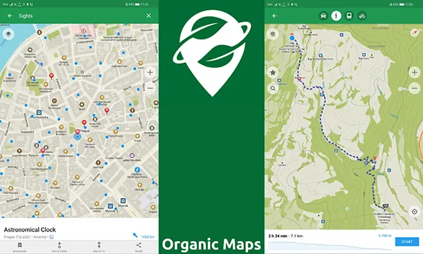
The application includes searchable points of interest such as accommodation, restaurants, transport hubs, museums and local attractions. Since the information comes largely from OpenStreetMap contributors, coverage is often detailed even in destinations that receive less attention from commercial mapping providers.
Route planning is available for driving, walking and cycling. Users can search for addresses, calculate journeys and save favourite locations for future reference. These functions remain available even when the device is completely disconnected from the internet.
Offline Navigation During International Trips
Many travellers prepare for journeys by downloading destination maps before leaving home. Once stored on the device, maps remain accessible regardless of mobile signal strength or local network availability.
This capability becomes especially useful when crossing borders, travelling through rural areas or exploring regions where data costs remain high. Offline maps help users avoid unexpected roaming charges while maintaining access to essential navigation tools.
As of 2026, Organic Maps supports extensive global coverage through OpenStreetMap datasets, allowing travellers to navigate major cities, small towns and remote areas across Europe, Asia, North America, South America, Africa and Oceania.
Cycling and Hiking Capabilities for Outdoor Activities
Beyond standard navigation, Organic Maps has become popular among cyclists and outdoor enthusiasts. The application includes numerous cycling routes, mountain trails, footpaths and terrain details contributed by the global OpenStreetMap community.
Cyclists can use the app to identify dedicated bike lanes, shared paths and low-traffic roads. In many regions, route information is detailed enough to support both urban commuting and long-distance cycling adventures.
Hikers benefit from offline access to trail networks, elevation information and geographic landmarks. Carrying offline maps can provide an additional layer of safety when travelling in forests, mountains or remote natural environments.
Why Outdoor Enthusiasts Choose Organic Maps in 2026
Battery efficiency remains an important consideration during long outdoor activities. Because Organic Maps works without continuous communication with external servers, power consumption can often be lower than that of heavily connected navigation applications.
The app’s clean interface focuses on practical navigation rather than advertisements or promotional content. This simplicity helps users access routes, maps and saved locations quickly, even while travelling in challenging outdoor conditions.
For Android users seeking a navigation solution that combines offline functionality, detailed OpenStreetMap coverage and strong privacy protections, Organic Maps continues to be a practical choice for travel, cycling and hiking in 2026.